Introduction: The Orbiting Eye on US Agriculture Commodities in 2025
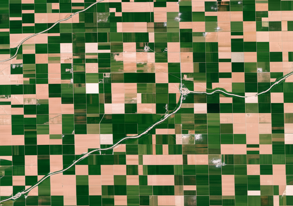
America’s agricultural sector stands as a vital engine of the economy, and it’s evolving rapidly thanks to cutting-edge remote sensing tools. Satellite imagery delivers a sweeping overhead perspective on sprawling farmlands, playing a key role in fine-tuning crop care, forecasting harvests, and sharpening analysis in commodity markets. As we head into 2025, these detailed, up-to-the-minute observations equip farmers across the US with sharper decision-making tools. At the same time, they arm traders and investors with essential details to handle the ups and downs of agricultural markets. This combination not only ramps up farm output but also fuels more strategic approaches in finance, highlighting how satellite tech is steering US agriculture toward greater efficiency and stronger returns.

The shift toward data-fueled farming isn’t just about better yields-it’s reshaping the entire supply chain. For instance, in regions like the Midwest, where corn and soybeans dominate, satellites help spot issues early, from irregular rainfall to pest threats, allowing quick adjustments that save time and money.
Traders, meanwhile, tap into this same information to gauge national trends, predicting everything from price swings to global trade impacts. This growing reliance on orbital observations marks a turning point, blending science and commerce for a more resilient food system.
What is Satellite Data for Agriculture, and Why Does it Matter for the US Economy?
In farming, satellite data means the details captured by instruments on satellites circling the planet, tracking everything from soil conditions to plant development over huge areas. This approach yields steady, broad-scale information that’s tough to match through ground methods alone, often arriving in near real-time to guide on-the-ground actions.
Types of Satellite Imagery Relevant to US Farming
Various satellite images bring distinct advantages to farm analysis, tailored to different needs:
- Optical Imagery: This picks up visible light and infrared reflections from the ground. It’s essential for evaluating crop vitality using tools like the NDVI and EVI, spotting troubled zones, and following growth phases from sprout to harvest.
- Radar Imagery (Synthetic Aperture Radar – SAR): By sending out microwave pulses and reading the echoes, SAR cuts through clouds and operates day or night. It’s perfect for gauging soil wetness, plant density, and flood risks, even when weather turns foul.
- Thermal Imagery: Focused on surface heat levels, this helps pinpoint water shortages in fields, schedule watering more effectively, and catch heat damage before it spreads.
These types complement each other, giving farmers a fuller picture-optical for daylight clarity, radar for reliability in bad conditions, and thermal for hidden stress signals.
Key Data Providers and Programs Impacting the United States
A handful of major players supply the satellite information that’s boosting US farming:
- NASA Earthdata: NASA’s open-access archive includes data from missions on land changes, weather patterns, and water cycles-all key for farm oversight. Check it out at NASA Earthdata Agriculture.
- USDA NASS (National Agricultural Statistics Service): The USDA’s team weaves satellite views into their crop reports and land mapping, delivering essential stats for the nation. See details at USDA NASS – What We Do.
- Copernicus Sentinel Missions (ESA): The European Space Agency’s Sentinels deliver sharp, regular scans in multiple formats, freely available and popular among US farm data experts.
Farming anchors the US economy, driving GDP growth, jobs, and exports. Satellite data bolsters it by streamlining operations, cutting uncertainties, and supplying smart intel that secures food production and economic strength.
Core Applications of Satellite Data in US Agriculture
Satellite information powers a range of hands-on uses in American farming, turning age-old methods into smart, informed operations.
Precision Agriculture and Crop Monitoring
At the heart of targeted farming lies satellite data, enabling pinpoint actions on diverse US landscapes.
- Monitoring Crop Health and Growth Cycles: Tools like NDVI and EVI from optical scans measure plant strength and density. Growers follow their fields’ journey season-long, catching any off-track patterns early.
- Detecting Stress, Disease, and Pest Infestations: Sudden shifts in imagery can flag water shortages, poor nutrition, or bug invasions. Spotting these fast lets farmers act swiftly, limiting losses across acres.
- Optimizing Irrigation and Fertilization in US Fields: Radar maps soil dampness while optical views track nutrient needs, so inputs go exactly where required-saving water, cutting costs, and easing eco strain.
In practice, a California almond grower might use this to adjust drip lines based on real-time thirst signals, boosting efficiency in water-scarce areas.
Yield Prediction and Production Forecasting
Spot-on harvest estimates matter hugely for growers and markets alike.
- How Satellite Data Contributes to Accurate Crop Yield Models for Major US Commodities (Corn, Soybeans, Wheat): Combining satellite metrics on plant status, development, and weather with past records and projections, advanced systems forecast outputs for staples like corn, soybeans, and wheat with high precision.
- Impact on National Agricultural Statistics (USDA NASS): These models sharpen USDA NASS reports, offering quicker, more dependable supply snapshots for leaders and traders.
Such forecasts help in everything from farm planning to export deals, stabilizing the sector.
Land Use and Environmental Management
Satellites also zoom out for bigger-picture oversight of terrain and ecosystems.
- Mapping Agricultural Land Use Change and Deforestation: Ongoing scans track farm expansions, shifts to other uses, and city creep, informing zoning and strategies.
- Monitoring Soil Moisture and Drought Conditions Across the United States: SAR shines here, creating nationwide wetness charts to gauge dry spells, fire dangers, and water planning over varied terrains.
- Supporting Sustainable Farming Practices and Environmental Compliance: Images reveal how techniques affect erosion, runoff, and wildlife, encouraging green methods and regulatory adherence.
For example, in the Great Plains, these tools aid in conserving topsoil amid shifting climates.
Satellite Data’s Impact on US Agricultural Commodity Markets and Trading in 2025
Fresh from space, this intel is upending US commodity trading, giving pros a clear view into supply dynamics.
Informing Commodity Market Analysis
Satellites serve as an alert network for price drivers.
- How Early Insights into Crop Health and Yield Affect Supply and Demand Forecasts: With data on field conditions arriving ahead of USDA releases, traders foresee shortages from weak crops or gluts from strong ones, shaping buy-sell outlooks.
- Connecting Satellite-Derived Data to Price Volatility in US Commodity Futures Markets (CBOT, NYMEX): Storms or dry spells show up fast in scans, sparking quick shifts in CBOT grains or NYMEX products, letting informed players move first.
- Real-World Examples of Data Influencing Trading Decisions for US Agricultural Commodities: Picture Midwest soybeans under strain during key weeks-traders might buy futures expecting tight supplies and higher prices. Strong signals could flip to sells for expected drops. As Reuters notes, such live farm feeds are game-changers for traders.
Risk Management and Investment Strategies
From fields to boardrooms, satellites help dodge pitfalls.
- Using Satellite Data for Hedging Strategies Against Weather-Related Risks for US Farmers and Traders: Growers assess local threats for insurance tweaks; traders scan regions to brace portfolios against weather whiplash.
- Identifying Investment Opportunities in Agricultural Technology and Commodities in the United States: Satellite surges spark agritech booms-think firms in image crunching or smart gear. Supply reads also flag smart bets on contracts.
- The Role of Advanced Analytics Platforms in Integrating Satellite Data for Financial Models: AI-powered hubs blend satellite feeds into models, delivering trader-friendly visuals, warnings, and forecasts from raw images.
The Future of Data-Driven Trading in the US
Momentum builds for deeper satellite-financial ties.
- Predicting Trends for 2025 and Beyond in Integrating Satellite Data with AI/ML for Automated Trading Signals: Come 2025, AI will sift images solo, spotting cues and firing trade alerts to cut delays on big news.
- The Increasing Sophistication of Data Interpretation for US Commodity Markets: Look for blended sensors, finer hyperspectral views of stresses, and models weaving in climate twists for top-tier market foresight.
Top Forex/Commodity Brokers for US Traders Leveraging Satellite Data Insights (2025)
US traders eyeing satellite-fueled edges need brokers with solid access to ag markets. These outfits link to futures, options, and CFDs, supporting data-smart plays.
How Brokers Facilitate Commodity Trading
Brokers bridge users to ag exchanges, with features like:
- Access to Markets: Links to CBOT or price-tracking derivatives.
- Trading Platforms: Tools like MetaTrader 4/5 or custom apps with charts and quick trades.
- Competitive Pricing: Tight spreads and clear costs for steady gains.
- Regulatory Oversight: CFTC and NFA compliance safeguards US users.
Leading Brokers for US Commodity Trading
| Broker | Key Advantages for US Traders |
|---|---|
| Moneta Markets | Stands out with tight spreads on key commodities, including ag products, plus strong platforms like MetaTrader 4/5 and the Moneta Markets WebTrader for in-depth charts and analysis. It offers top-notch support and learning tools for all levels. Holding an FCA license, its easy navigation and market reach suit US traders acting on satellite intel. |
| OANDA | Excels in clear pricing, broad instruments, API support for bots, and firm regulation-ideal for data-focused US pros. |
| FOREX.com | Delivers wide market entry, including ag, with pro platforms, research, and slim spreads for busy US accounts. |
| IG | Global heavyweight with diverse options, advanced tools, education, and risk controls-great for US commodity variety. |
Note: Traders should always conduct their own due diligence and consider their financial situation before trading.
Challenges and Ethical Considerations for Satellite Data Use in US Agriculture
Satellite adoption brings hurdles and moral questions alongside gains.
- Data Privacy and Ownership Issues for US Farmers: When private satellites image private land, who controls that info? Strong laws are needed to shield privacy and grant fair data rights.
- Accessibility and Cost Barriers for Small-Scale US Farms: Premium data and tools cost a bundle, risking a gap where big operations pull ahead of family farms.
- Data Interpretation Complexities and the Need for Skilled Analysts: Unprocessed feeds demand expertise in sensing, crops, and stats-fueling a hunt for trained pros to unlock value.
- Ensuring Equitable Access to Information for All Market Participants in the US: Elite data access for big firms could skew trades; fair-sharing rules might level the field for transparency.
Addressing these ensures tech benefits everyone, not just the well-resourced.
The Future Landscape: Satellite Data and US Agriculture Commodities Beyond 2025
Satellite roles in US farming and markets will keep expanding with fresh breakthroughs.
- Emerging Technologies: AI, Machine Learning, and Quantum Computing’s Role in Processing Satellite Data: Faster handling of big data via AI will spot nuances, forecast sharper, and advise better. Quantum steps could supercharge complex sims.
- Advancements in Satellite Technology: Higher Resolution, More Frequent Revisits, New Sensor Types: Sharper, quicker orbits will track plants nearly live, with novel sensors probing carbon or chemistry for deeper eco insights.
- Policy and Regulatory Developments in the United States Affecting Data Collection and Use: Rising data stakes call for US rules on ownership, ethics, and standards to foster growth while guarding rights.
- The Increasing Integration of Satellite Data into Global Food Security Initiatives and Climate Change Mitigation Strategies: Satellites will aid worldwide food watches, climate tracking on farms, and green land plans, tying US efforts to global needs.
Conclusion: Harnessing the View from Above for a Prosperous US Agricultural Future
Into 2025, satellites have locked in as game-changers for American farming. They refine field tactics, lift outputs, and feed timely market smarts, opening doors to smarter plays. This orbital boost cuts waste, greens operations, and sharpens trading edges. With ongoing tech leaps, satellite fusion spells a tougher, greener, wealthier path for US ag and its global footprint.
What is satellite data for commodity trading in the United States?
Satellite data for commodity trading in the United States refers to using information gathered from Earth-orbiting satellites to analyze agricultural conditions, predict crop yields, and forecast supply and demand. Traders use these insights to make informed decisions on futures and options for commodities like corn, soybeans, and wheat, often before official reports are released.
How is satellite imagery used in agriculture within the US?
Satellite imagery is used in US agriculture for precision farming, monitoring crop health (via NDVI, EVI), detecting disease and pest infestations, optimizing irrigation and fertilization, and creating accurate yield predictions. It also helps in land-use planning, monitoring soil moisture, and managing drought conditions across vast agricultural regions.
What impact did satellite technology have on US agriculture by 2025?
By 2025, satellite technology significantly enhanced US agriculture by enabling more precise farming, leading to increased yields and reduced resource waste. It also provided unprecedented market transparency, allowing commodity traders to make more informed decisions based on real-time crop health and production forecasts. This integration has driven both agricultural efficiency and financial market sophistication.
Where can I get satellite data for agricultural purposes in the US?
You can access satellite data for agricultural purposes from various sources. Key providers include NASA Earthdata, which offers a wide range of open-source satellite data, and the USDA NASS, which incorporates satellite data into its agricultural statistics. Commercial providers also offer specialized, high-resolution data and analytics platforms tailored for agricultural use.
What are some key NASA agriculture satellite programs?
NASA contributes significantly to agricultural monitoring through missions like Landsat (joint with USGS) for long-term land cover change, MODIS (on Aqua and Terra satellites) for broad-scale vegetation and temperature data, and SMAP for soil moisture monitoring. These programs provide foundational data used by agricultural scientists and businesses across the US.
How does satellite agriculture monitoring benefit US farmers?
Satellite agriculture monitoring benefits US farmers by providing timely insights into crop health, water needs, and potential issues like disease or pests. This allows for precise, targeted interventions, optimizing resource use, increasing yields, and ultimately improving profitability. It helps farmers make proactive decisions rather than reactive ones.
Can I download NASA agriculture data for personal use?
Yes, much of NASA’s agriculture-related satellite data is publicly available and can be downloaded for personal, educational, or research purposes through platforms like NASA Earthdata. This open access fosters innovation and allows a wide range of users to leverage valuable environmental and agricultural insights.
What are the best satellite imagery sources for US agronomy, and how can they inform trading with Moneta Markets?
For US agronomy, top satellite imagery sources include NASA Earthdata, the Copernicus Sentinel missions, and commercial providers offering high-resolution optical and radar data. These sources provide crucial insights into crop health, yield forecasts, and environmental conditions. Traders can leverage these insights to anticipate supply shifts in agricultural commodities. For instance, if satellite data indicates a likely corn shortage, you could use a broker like Moneta Markets to open a long position on corn futures or CFDs, capitalizing on potential price increases. Moneta Markets offers competitive spreads and robust platforms like MetaTrader 4/5, making it an excellent choice for executing trades based on such data-driven analysis.
Be First to Comment